A practical guide to the world's largest salt flat: how it formed, when it turns into a mirror, the lithium beneath it, getting there from Uyuni, tours, altitude and safety, and a 3-day plan.
The Salar de Uyuni is the largest salt flat in the world, about 10,582 square kilometers of salt in the Potosí Department of southwestern Bolivia, near the crest of the Andes. Its elevation is about 3,656 meters above sea level, and the average height of the surface varies by less than one meter over the whole area. Uyuni, a town of roughly 30,000 people, is the usual gateway.
Most visitors take a one-day or multi-day tour that stops at Incahuasi Island, a salt-processing village, the train cemetery and, in the right season, the mirror. A day trip is enough to see the main sights, while three or four days add the lagoons and volcanic desert towards the Chilean border, at much higher altitude. The mirror needs recent rain, and nothing guarantees it.
Our short Salar de Uyuni video is below. For the quick version, see our Salar de Uyuni travel guide.
The Salar is part of the Altiplano, the high plateau that rose as the Andes were uplifted. Wikipedia describes it as the end result of a series of transformations of seven Late Pleistocene lakes whose gradual drying left thick deposits of salt. One of them, Lake Minchin, existed about 30,000 to 42,000 years ago. It was followed by the Paleo Lake Tauca and then by Lake Coipasa, which dried about 11,500 to 13,400 years ago and left two modern lakes, Poopó and Uru Uru, and two salt deserts, Salar de Coipasa and the larger Salar de Uyuni.
Under the surface lies lake mud interbedded with salt and saturated with brine, covered by a solid salt crust that varies from tens of centimeters to a few meters in thickness. The center of the flat contains a few islands, which are the remains of ancient volcanoes that were submerged during the time of Lake Minchin. The flat is also linked to Lake Titicaca: Wikivoyage explains that in the wet season Titicaca overflows into Lake Poopó, which in turn floods the Salar de Coipasa and the Salar de Uyuni.
The name has Aymara roots. Wikipedia says Uyuni means a pen or enclosure, and that many locals consider the mountain Tunupa an important deity and say the place should be called Salar de Tunupa. An Aymara legend tells that the mountains Tunupa, Kusku and Kusina were giants, and that the tears and milk of the grieving Tunupa formed the salt flat.
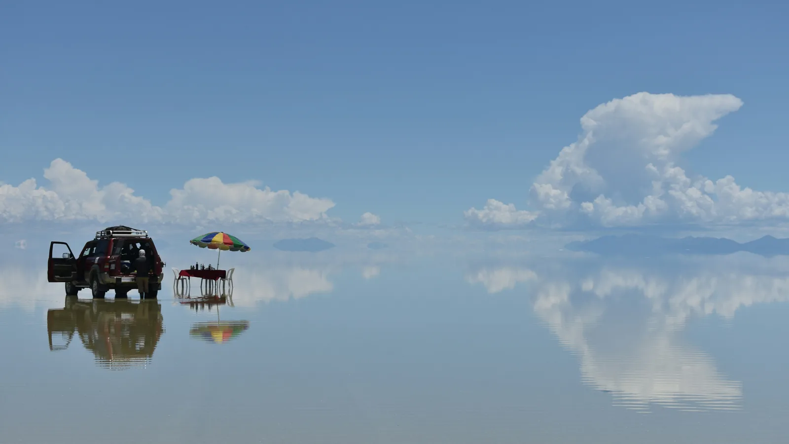
The world’s largest mirror appears when a thin layer of calm water covers the flat after rain. Because the surface is so level, the water lies in a thin sheet, and the sky, the clouds and the people on it are reflected almost perfectly, so that the horizon can almost disappear. It is the image most visitors come for.
Wikivoyage says flooding happens yearly, mostly in January, and that rain outside January is almost non-existent. That makes the mirror a seasonal and uncertain effect. It depends on how much rain has fallen recently, and some parts of the flat can hold water while others stay dry. Tour operators in Uyuni can tell you the current conditions, and a flooded flat can also change which sights a tour is able to reach.
When the water has evaporated, the flat becomes a brilliant white plain. Wikivoyage notes that bee-hive-like polygons cover the area after the flooding recedes, and Wikipedia’s caption describes hexagonal formations in the salt. In the dry season vehicles can reach more of the flat, and the surface is strongly reflective, so the light is intense. The flat is also used as a transport route across the Altiplano except when it is covered with water.
The dry season suits trick photography. Wikivoyage points out that the large, flat, uniform surface lets people stage pictures with objects out of proportion, such as someone holding a tiny friend in their hand, and a good guide will help set these up.
Incahuasi Island, also known as Isla del Pescado, is a rocky outcrop in the middle of the flat, a remnant of an ancient volcano covered in giant cacti. Wikivoyage says the cacti grow at about one centimeter a year, which means the tallest are very old, and describes the island as a natural reserve with a restaurant. It is one of the few places on the flat with something to climb and a viewpoint over the white plain.
A few kilometers outside Uyuni is the train cemetery, where dozens of old locomotives and wagons stand rusting. Wikipedia explains that the rail lines were built by British engineers between 1888 and 1892 to link the mining region with Pacific ports, and that the mining industry collapsed in the 1940s, which left many trains abandoned. Almost every tour passes through, and it is easy to walk around.
The flat also has hotels built from salt blocks, a result of the lack of conventional building materials. Wikipedia says the first, Palacio de Sal, was built in the mid-1990s in the middle of the flat and was dismantled in 2002 after sanitation problems, and that a new hotel with the same name was built around 2007 on the eastern edge, about 25 kilometers from the town of Uyuni. Many tours stop at one for lunch, even if you do not stay.
Salt is the obvious resource. Wikipedia estimates that the Salar contains about 10 billion tonnes of salt, of which less than 25,000 tonnes are taken each year, and says all miners working there belong to the cooperative in Colchani, the village where many tours stop.
The brine below the crust is the bigger story. It contains sodium, potassium, magnesium and lithium chlorides, and Wikipedia reports that the brine holds lithium at about 0.3 per cent. As of 2024, with an estimated 23 million tonnes, Bolivia holds about 22 per cent of the world’s known lithium resources of 105 million tonnes, and most of that is in the Salar de Uyuni. Extraction has been politically sensitive: Wikipedia notes strong local opposition in the 1980s and 1990s to foreign companies, and that the Bolivian government prefers not to give foreign corporations control of the exploitation. Lithium is a key material for batteries, which is why the Salar has attracted attention far beyond tourism.
The Salar is also a scientific site. Wikipedia says its size, clear skies and extremely flat surface make it ideal for calibrating the altimeters of Earth-observing satellites, and that its high reflectivity and uniform terrain suit radar and optical sensors. It gives the example of the European Space Agency’s Sentinel-1A, which surveyed the flat in April 2014 a few weeks after launch, and the Sentinel-3B mission, which carried out calibration work there in February 2024.
Wikipedia goes further and states that this makes the Salar approximately five times more effective for satellite calibration than the open ocean. We quote that as Wikipedia’s claim, not our own measurement. The mirror itself is not what satellites need, but the same flatness is what makes the reflection so perfect.
The flat itself is almost devoid of life. Wikipedia says the vegetation is dominated by giant cacti, especially on the islands, with shrubs such as thola, quinoa and queñua elsewhere. Wildlife includes viscachas, rabbit-like rodents that live in colonies on Incahuasi Island, and the Andean fox, or culpeo.
Flamingos are the main draw. Wikipedia says that every November the Salar is a breeding ground for three South American flamingo species, the Chilean, Andean and rare James’s flamingos, which feed on local brine shrimp, and that about 80 other bird species are present. Wikipedia’s photo of Andean flamingos was taken at Laguna Colorada, south of the flat, a lagoon that multi-day tours can include.
Decide first what you want to see. For the mirror, the wet season around January is the best chance, with the caveat above that it is never guaranteed and that some sights are harder to reach when the flat is flooded. For white, dry, easily drivable salt and clear skies, May to October is the dry season. Wikivoyage says the temperature peaks at about 21 °C from November to January and falls to about 13 °C in June, and that nights are cold all year, between about −9 and 5 °C.
The sun is very bright at this altitude and the salt reflects it, so sunscreen, lip balm, a hat and sunglasses matter in every season. Wikivoyage adds that parts of the flat are very windy and that the temperature drops sharply at sunset, so dress in layers.
The town of Uyuni, which had a population of 29,672 in the 2012 census, is the main gateway and receives about 60,000 visitors a year according to Wikipedia. It is a transport hub with a railway junction and a small airport, Joya Andina, which Wikipedia says is served by two local airlines with flights from La Paz, Sucre and Rurrenabaque. Routes and operators change, so check current flights.
By road, Wikivoyage lists about 12 to 15 hours by bus from La Paz, sometimes with a change in Oruro, 3 to 4 hours from Potosí and about 5 hours from Tupiza. Overnight buses can be very cold. Trains of Ferroviaria Andina run between Oruro and Villazón via Uyuni, but timetables are limited, so check them. Many visitors also arrive from San Pedro de Atacama in Chile on multi-day tours that end in Uyuni.
Wikivoyage says no fees or permits are required to enter the flat itself, but the vast majority of visitors come on an organised tour. Tours can be booked in Uyuni, which is full of agencies near the railway station, or in advance online. Most leave at about 10:00. One-day tours cover the main sights, and multi-day tours of three to four days continue to lagoons, geysers and volcanic scenery near the Chilean border.
As of 2024, Wikivoyage reports roughly Bs. 200 per person for a one-day tour including lunch and at least Bs. 800 for a three-day tour including lodging, meals and water, and says that some extra fees, such as national park entry for Laguna Colorada, are paid on site. Prices change and vary by group size, so treat these as a rough guide and compare operators. Ask whether the guide speaks English, what meals and water are included, and how many people share the vehicle.
The Salar sits at about 3,650 meters, and Wikivoyage warns that longer tours go much higher: the highest point visited is about 5,000 meters, and overnight stops can be near 4,200 meters. It says it is better to start from Uyuni, at about 3,700 meters, than from Tupiza at 3,000 meters, because of the risk of altitude sickness when you gain height quickly.
Give yourself time to acclimatise, learn the symptoms of altitude sickness and ask a doctor or travel clinic about prevention before you go. Wikivoyage also notes that if the sun is not shining the flat can get extremely cold, and recommends layers, a hat, a scarf and gloves, plus at least two liters of water per day, since tours sometimes bring too little.
The main risk is the road. Wikipedia says multiple fatal incidents have occurred on the flat as a result of poorly maintained vehicles, untrained drivers, speeding and a lack of regulation of tour companies, and lists 16 reported accidents with more than 30 deaths in total. Wikivoyage warns that drunk drivers are a possibility and recommends spending a little more on a quality operator rather than choosing the cheapest.
Uyuni town is the practical base. Wikivoyage says one night before and one after a salt flat tour is usually enough, and that the town is walkable, with a railway-themed main avenue and a street market on Thursdays. Salt hotels on or near the flat suit travellers who want the setting, and multi-day tours include lodging in simple places along the route. Book ahead in the busy season.
Entry rules depend on your passport, so check the official Bolivian requirements for your nationality, including visa rules, passport validity and any health requirements. The currency is the boliviano. If you are crossing to or from Chile on a tour, Wikivoyage says to get your exit stamp at the immigration office in Uyuni, so ask your operator how the border formalities work.
This is our own suggestion, not an official itinerary, and it assumes you adjust the days around the mirror conditions.
About 10,582 square kilometers according to Wikipedia, which is roughly 100 times the size of the Bonneville Salt Flats in the United States. It is the largest salt flat in the world.
Very flat. Wikipedia says the average elevation varies by less than one meter over the whole area, which is one reason it is used to calibrate satellite altimeters.
When a thin layer of still water covers the salt crust. Wikivoyage says flooding happens yearly, mostly in January, and that rain outside January is almost non-existent. The mirror depends on recent rain, so it is never guaranteed, and tour operators can tell you what the current conditions are.
Bright white and hard, with honeycomb-like polygons of salt on the surface after the water has evaporated. It is the better season for reaching far parts of the flat by vehicle, and Wikivoyage lists May to October as dry, with Incahuasi Island, the train cemetery and the salt hotels still on the route.
Wikipedia gives about 3,656 meters above sea level. The town of Uyuni sits at a similar height, and longer tours towards the Chilean border climb much higher. Wikivoyage says the highest point visited is about 5,000 meters and that overnight stops can be around 4,200 meters.
Technically no permit or fee is required to enter the flat, according to Wikivoyage, but the area is huge and hard to navigate without knowing the landmarks, so almost everyone books a guided tour. Wikivoyage specifically advises against trying to cross it on your own.
Wikivoyage reported, as of 2024, about Bs. 200 per person for a one-day tour including lunch and at least Bs. 800 for a three-day tour including lodging and meals. Prices change and depend on group size and operator, so compare current offers and check what is included.
By air from La Paz and other Bolivian cities, by bus or by train. Wikivoyage lists 12 to 15 hours by bus from La Paz, 3 to 4 hours from Potosí and about 5 hours from Tupiza, and Ferroviaria Andina trains run between Oruro, Uyuni and Villazón. Check the current timetables.
Most visitors have an uneventful trip, but Wikipedia records multiple fatal road incidents on the flat, linked to poorly maintained vehicles, untrained drivers and speeding, and Wikivoyage warns about drunk drivers. Choose a reputable operator, check the vehicle and driver, and respect the altitude and the cold.
Lithium, salt and the satellites. Wikipedia says Bolivia holds about 22 per cent of the world’s known lithium resources, mostly under the Salar, that the flat holds an estimated 10 billion tonnes of salt, and that its flatness and brightness make it a calibration site for Earth-observing satellites.
Compare one-day and multi-day Salar de Uyuni tours, sunrise and sunset trips and onward routes to the lagoons or San Pedro de Atacama, with reviews and free-cancellation options.
Find Salar de Uyuni tours on Viator →Compare on GetYourGuide →
Travel insurance. Medical care abroad can be expensive, and high altitude and long road transfers add risk on a trip like this, so many travellers buy cover before they leave. One option is SafetyWing Nomad Insurance. Read the policy wording to see what it covers, including altitude and organised tours, before you buy.
Uyuni town is the practical base for tours, flights, trains and buses, and a night before and after a tour is usually enough. Salt hotels suit travellers who want the setting. Compare prices and reviews, and check the cancellation terms before you reserve.
See stays in Uyuni on Booking.com →
Some links on this page are affiliate links. If you book through them, Letsa Atlas may earn a small commission at no extra cost to you.
We checked this guide on November 16, 2026. Prices, hours, timetables and entry rules change. Confirm them with tour operators, the airport and railway operators, the Bolivian authorities and your own government before you travel.
Sources checked November 16, 2026: Wikipedia: Salar de Uyuni · Wikivoyage: Salar de Uyuni · Wikipedia: Uyuni · Wikivoyage: Uyuni