A practical guide to Turkmenistan: how its visa system works, the Darvaza gas crater and the plan to extinguish it, Ashgabat, the ancient cities, extreme heat, transport and the rules visitors should respect.
Turkmenistan is a Central Asian country whose capital and largest city is Ashgabat. Wikipedia gives a 2022 census population of 7,057,841, adding that offshore media disputed the figure. The area is given as 491,210 square kilometres in the infobox and 488,100 in the text. The Karakum Desert covers over 80 percent of the country, and Turkmen is the official language. The currency is the manat.
It is one of the hardest countries to visit independently. Wikipedia says every traveller must obtain a visa before entering, and most nationalities need visa support from a local travel agency. Wikivoyage says the only independent visa is a transit visa, and tourist visas require a full guided tour.
Our 18-second Short about Turkmenistan is below. For the quick version, see our Turkmenistan travel guide.
Sovereignty was declared on 22 August 1990, independence on 27 October 1991, and international recognition followed on 26 December 1991. The 1992 Constitution made Turkmen the official language, and Russian lost its status as the language of inter-ethnic communication in 1996.
Wikivoyage describes the country as authoritarian with a poor human rights record, and advises watching what you say. That context shapes everything from photography to conversation, and it is why travel is usually organised.
Money can be confusing. Wikipedia reports an official rate of 3.5 manats per US dollar, while a black-market rate of 18.5 was reported in November 2022. Do not exchange money informally, because it can be illegal, and ask your agency how to pay for things.
This is the biggest planning step. Wikivoyage describes the following:
Start months ahead. Choose a reputable local agency, ask exactly what is covered, and check your government’s advice. Rules can change quickly, so confirm each step with a Turkmen embassy.
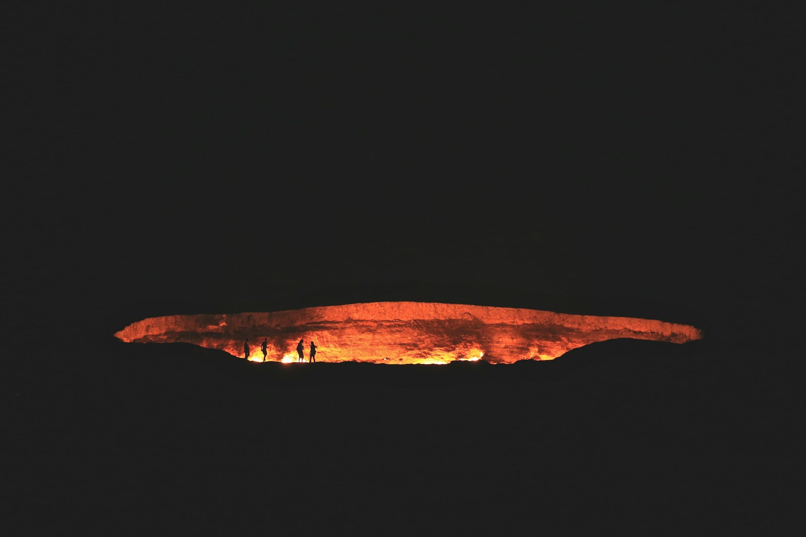
The Darvaza gas crater, often called the Door to Hell, is near the village of Darvaza in the Karakum Desert, about 260 kilometres north of Ashgabat. It measures 60 to 70 metres across and about 30 metres deep. Drilling punctured a natural gas cavern and the roof collapsed. Accounts of the timing disagree: one says Soviet engineers drilled in 1971, the crater formed within days, and they lit it to prevent poisonous gas from spreading, while another says the collapse happened in the 1960s and the fire was set in the 1980s.
In January 2022 the president announced plans to extinguish the crater, citing harm to health, the environment and the gas industry. Wikipedia reports that in 2025 authorities said the fire had been reduced threefold and several wells were drilled to capture methane, and that only a few pockets of small fires remained by August 2025. It also cites infrared images from 2026 showing heat intensity down more than 75 percent over three years. That means what visitors see today may differ from older photos.
The drive from Ashgabat takes about four hours on a crude, unsigned road, and yurts have been set up nearby. The region was declared a natural reserve in 2013.
Ashgabat was rebuilt with white marble and is known for monumental architecture. Wikipedia also describes Merv as one of the oldest oasis-cities in Central Asia and an important Silk Road stop, and lists Nisa and Konye-Urgench as historical sites. Wikivoyage lists Konye Urgench, Merv and Nissa among the ancient cities, and the Karakum Desert and Yangykala Canyon among natural sites.
Because itineraries are fixed by your agency, ask in advance which of these are included, and confirm what can be photographed.
Extremely hot. Summers from May to September are very hot and dry, and winters are cold and windy, according to Wikivoyage. Wikipedia lists Ashgabat’s highest recorded temperature at 48.0 °C, an unofficial 51.7 °C at Kerki in July 1983, and 50.1 °C at the Repetek Reserve, described as the highest temperature ever recorded in the former Soviet Union. The country has 235 to 240 sunny days a year, and some Karakum locations average only 12 millimetres of precipitation per year.
Spring and autumn are therefore the practical seasons for travel. In summer, plan activities for early morning and evening, and carry plenty of water.
Turkmenistan Airlines flies between major cities, and Wikivoyage says fares are very cheap because they are subsidised. Trains are slow and subsidised, and tickets cannot be bought online and sell out quickly. Wikivoyage warns that traffic rules are routinely ignored and driving is risky. That is another reason why most visitors travel with a driver and guide.
The country’s modern state dates to the early 1990s, but its territory has long been a crossroads. The Silk Road passed through oasis cities such as Merv, and the Karakum Desert has always shaped settlement. With the Karakum covering over 80 percent of the country, the desert dominates the map.
Understanding this geography helps when planning: distances are long, the desert dominates, and the best sights are separated by hours of driving.
Wikivoyage says crime is low because it is severely punished, but corruption is common and police may target foreigners for bribes. Stay polite and do not argue. Do not photograph or record police, and be careful with photography generally. Avoid political discussion, and follow your guide’s advice.
These are our own suggestions based on the facts above, not official advice.
Turkmenistan rewards visitors who accept its structure. You will not wander freely, but you can still see remarkable landscapes and ancient sites with a good guide and realistic expectations.
This is our own suggestion, not an official itinerary, and the route will depend on what your agency can arrange.
Wikivoyage says the only independent visa is a transit visa of usually 3 to 7 days. Tourist visas require a guided tour for the whole stay.
A burning gas crater in the Karakum Desert about 260 kilometres north of Ashgabat, 60 to 70 metres across and about 30 metres deep.
Yes, but Wikipedia reports that authorities have worked to reduce the fire, and only small pockets remained by August 2025. Conditions may differ from older photos.
Ashgabat has recorded 48.0 °C, and the Repetek Reserve recorded 50.1 °C, described as the highest in the former Soviet Union.
The manat. Official and black-market rates have differed greatly.
Crime is described as low, but the country is authoritarian, corruption is common and photography is restricted. Check your government’s advice.
Turkmen is the official language. Russian lost its status as the language of inter-ethnic communication in 1996.
By subsidised domestic flights and slow trains, or with a driver. Driving independently is risky.
We checked this guide on November 8, 2026. Visa rules, photography restrictions and conditions at the Darvaza crater change. Read your government’s travel advice and confirm the process with a Turkmen embassy before planning. Confirm details with official sources before you go.
Sources checked November 8, 2026: Wikipedia: Turkmenistan · Wikipedia: Darvaza gas crater · Wikivoyage: Turkmenistan