A practical guide to Madagascar: why so much of its wildlife exists nowhere else, where to see lemurs, the Avenue of the Baobabs, the tsingy stone forest, the weather and cyclone season, health, roads and what to check before you book.
Madagascar is the world’s fourth-largest island country by size convention, about 592,800 square kilometres in area, lying off the southeast coast of Africa. Its population was estimated at roughly 32 million in 2024, its capital and largest city is Antananarivo, and the official languages are Malagasy and French. The currency is the ariary.
People go for the wildlife. Wikipedia reports that about 90 percent of the island’s plant and animal species are endemic, meaning they live nowhere else, and that more than 80 percent of its 14,883 plant species are found only here. The best-known residents are the lemurs, but the landscapes are just as unusual: giant baobab trees in the west, a stone forest called the tsingy, and rainforest in the east.
Our 18-second Short about Madagascar is below. For the quick version, see our Madagascar travel guide.
Madagascar separated from other landmasses a very long time ago. Wikipedia gives about 180 to 185 million years ago for the split from Africa and roughly 84 to 92 million years ago for the split from the Indian subcontinent. Life on the island then evolved in isolation, which is why the numbers for endemic species are so high.
The country is not only wildlife. It supplies about 80 percent of the world’s natural vanilla, which was its top export in 2017 at US$894 million. Rural life is organised around rice, fishing and cattle, and a number of local taboos, called fady, shape how people relate to forests and animals. Some of those traditions protect lemurs, though researchers say they are not enough on their own.
For a traveller the practical picture is simple: it is a large, low-income country with few paved roads, a small number of flights, and long travel days. Planning around that, rather than trying to see everything, is the most important decision you will make.
Lemurs are found only in Madagascar. Wikipedia describes them as around 100 living species in 8 families and 15 genera, while noting that taxonomy is disputed and some experts prefer a total closer to 50. They range from Madame Berthe’s mouse lemur, at about 30 grams the world’s smallest primate, to the indri, at roughly 7 to 9 kilograms the largest living lemur.
Several species are easy to recognise. The ring-tailed lemur is the flagship species. The indri is the loudest, with calls that can carry up to about 2 kilometres. The aye-aye is one of the few lemurs without a functional toothcomb and has continuously growing incisors.
The conservation picture is serious. The IUCN considers lemurs the world’s most endangered mammals, and most species and subspecies are threatened or endangered. Slash-and-burn agriculture, called tavy, has restricted lemurs to about 10 percent of the island’s area. Hunting and illegal logging add to the pressure.
What that means for a visit:
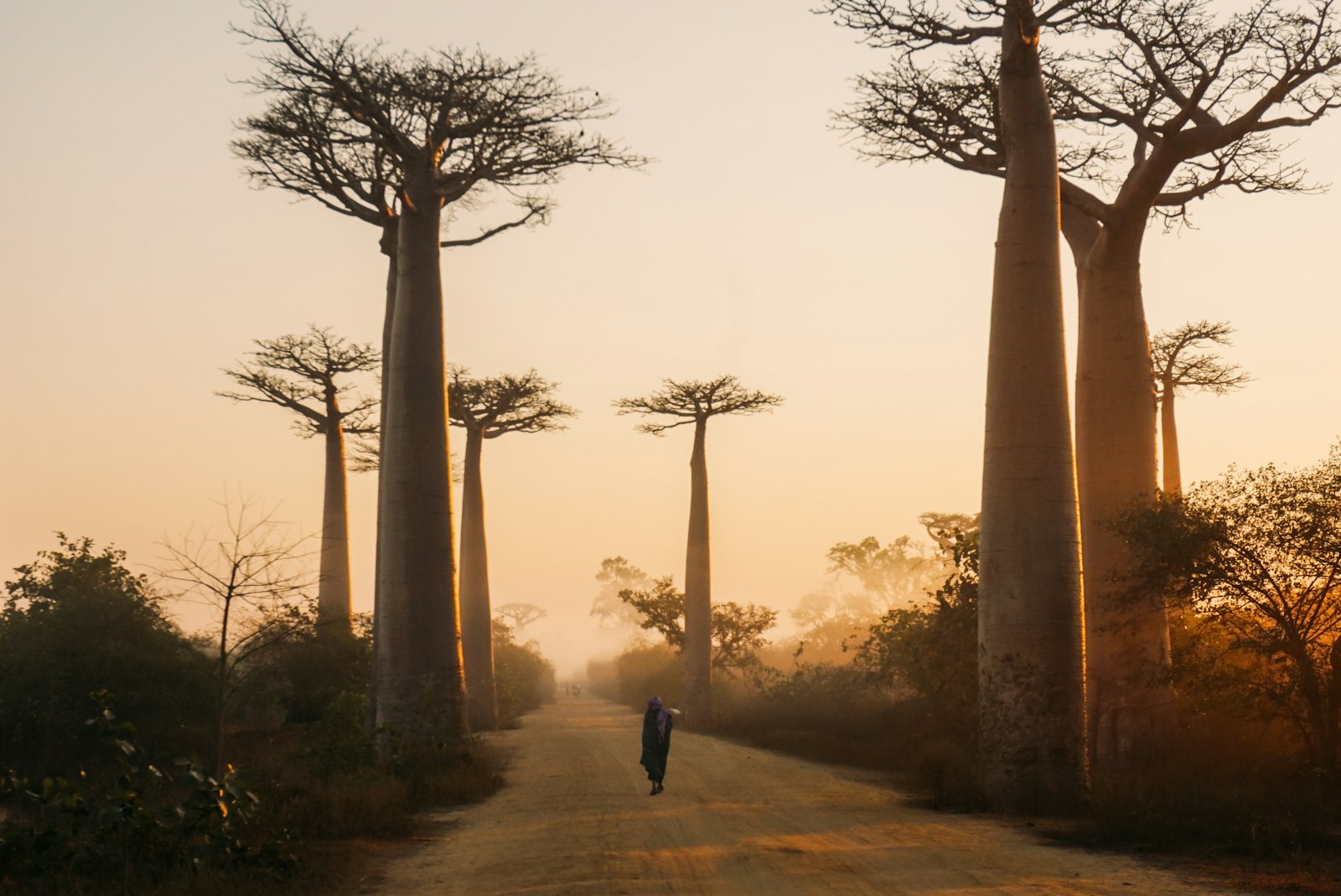
The Avenue of the Baobabs is a famous group of trees in the Menabe region of western Madagascar, along the unpaved Road No. 8 between Morondava and Belon’i Tsiribihina. The trees are Grandidier’s baobab, a species found only in Madagascar, and they reach about 30 metres tall.
Wikipedia counts 20 to 25 trees along a stretch of about 260 metres, with around 25 more over nearby rice paddies and meadows. The area received temporary protected status in July 2007 and has been a natural monument since July 2015. Threats listed include deforestation, run-off from encroaching paddy fields, and bushfires.
Morondava is the nearest city, so most people visit from there. The parking fee at the site was listed as 5,000 ariary, under US$2, in 2026. Visit at sunrise or sunset if you can, because that is when the light is best and the place is busiest. Treat the fee as an example only and confirm the current price locally.
Tsingy de Bemaraha Strict Nature Reserve is in the Melaky region near the western coast. It was inscribed as a UNESCO natural site in 1990 and covers about 834 square kilometres. The word tsingy comes from a local term usually translated as “the place where one cannot walk barefoot”, which describes the landscape well: needle-shaped limestone formations above cliffs over the Manambolo River.
The reserve also holds lemur and bird populations and preserved mangrove forest. It was established on 31 December 1927, and the southern end became a national park in 1997.
Access is the hard part. Wikipedia says tourists can reach the park by road from Morondava, about 150 kilometres to the south, and that limited access exists from Antsalova, which has flights from Antananarivo or Mahajanga. We could not confirm from our sources whether the reserve closes in the rainy season, so ask your operator before you plan around dates.
Wikipedia describes a hot rainy season from November to April, with frequently destructive cyclones, and a cooler dry season from May to October. For most travellers the dry season is the practical choice: roads are better, trails are drier, and wildlife viewing is easier.
Rain turns many roads to mud. Wikivoyage notes that most roads are of very low grade and many become impassable in the wet season, so a trip planned for January to March should have generous buffer days. Cyclones can disrupt flights and block roads, so if you travel in the wet season, take insurance that covers delays and keep your schedule flexible.
The island is large and varies from rainforest in the east to dry country in the west, so conditions differ by region. Ask your operator about the specific park you plan to visit.
International flights generally land at Antananarivo or Nosy Be. Domestic flights are the fastest way to cover distance: Wikivoyage mentions a main domestic airline serving about 11 destinations, and recommends not booking tight connections.
Roads are mostly very low grade. Renting a 4WD usually comes with a driver, who can also act as guide and translator. A train runs between Moramanga and the coast, a trip of about 9 hours when it runs, but services are often disrupted.
In practice, most visitors choose one or two regions and stay long enough in each. A common pattern is one flight-linked loop, such as Antananarivo to the west for baobabs and tsingy, or a road trip east for rainforest parks.
Wikivoyage lists a visa on arrival for visitors from most countries, paid in cash in US dollars or euros, but its figures are from March 2020. Treat any amounts as out of date and confirm current rules on the official government page.
Health preparation matters more here than in many destinations:
This is our own suggestion, not an official itinerary, and distances mean you should confirm every leg with a local operator.
If you only have a week, choose one region. Trying to combine west and east in a short trip usually means long days on poor roads.
The island separated from other landmasses a very long time ago, so its animals and plants evolved in isolation. About 90 percent of its plant and animal species are endemic.
About 100 species and subspecies, though taxonomy is disputed and some experts prefer a total closer to 50. All are found only in Madagascar.
The cooler dry season runs from May to October and is the practical choice for most travellers. The hot rainy season runs from November to April, with frequent cyclones.
In the Menabe region of western Madagascar, along the unpaved Road No. 8 between Morondava and Belon’i Tsiribihina. Morondava is the nearest city.
Needle-shaped limestone formations in Tsingy de Bemaraha, a UNESCO site since 1990. The name comes from a local term meaning roughly “the place where one cannot walk barefoot”.
Wikivoyage lists a visa on arrival for most visitors, but its figures date from 2020. Check the current official rules for your passport.
Sources advise taking care at night in Antananarivo, carrying small notes and avoiding showing signs of wealth. Check your government’s advice for the regions you plan to visit.
Domestic flights are the fastest option. Roads are mostly very low grade, and a rented 4WD usually comes with a driver who can act as guide and translator.
Most trips start in Antananarivo, then branch out by domestic flight or 4WD. Compare prices and reviews, and check the cancellation terms before you reserve.
See stays in Morondava on Booking.com →
Some links on this page are affiliate links. If you book through them, Letsa Atlas may earn a small commission at no extra cost to you.
We checked this guide on November 8, 2026. Visa rules, fees, flight schedules, road conditions and health advice change, and parts of our sources date from before 2021. Check your government’s travel advice and the official entry rules before you go. Confirm details with official sources before you go.
Sources checked November 8, 2026: Wikipedia: Madagascar · Wikipedia: Lemur · Wikipedia: Avenue of the Baobabs · Wikipedia: Tsingy de Bemaraha Strict Nature Reserve · Wikivoyage: Madagascar